Busan’s Population Shift Has Outgrown Its District Map
Busan’s population and living zones have moved far beyond the district map completed in 1995, reopening questions over old-core mergers, local finance and stronger administration within its growth districts.


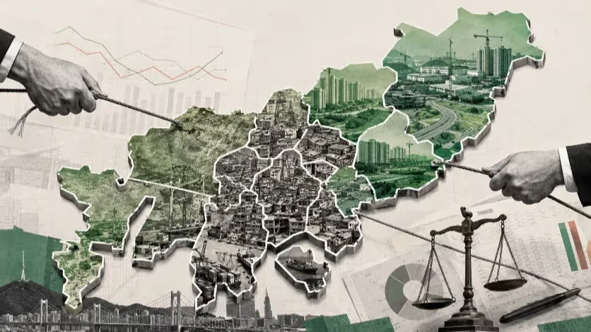
Busan still divides money, services and political responsibility through an administrative system completed near its population peak. Three decades of decline, ageing and outward growth have left four governments sharing the old centre, while several outer districts contain communities that increasingly depend on separate urban systems.
Roads still climb Yeongdo’s steep residential slopes after many of the households they were built to serve have disappeared. The island’s retaining walls, drainage lines, coastal infrastructure and neighbourhood bus routes remain fixed to the terrain, while older residents navigate streets and stairways shaped during a more populous period.
Housing data show how much of that earlier city remains. In a comparison of Busan’s 15 autonomous districts and Gijang-gun, 57.81 percent of Yeongdo-gu’s homes were classified as ageing and 14.35 percent as vacant. Empty and deteriorating properties add inspection, fire-safety and sanitation work to neighbourhoods where access is already difficult. The public network still covers the same island, even as fewer residents live around it.
Across the Nakdonggang River, Gangseo-gu is paying for a city at the other end of its development cycle. Myeongji International New City, Busan Eco Delta City, industrial estates and logistics facilities have placed apartment districts and employment sites beside farmland, older villages and widely separated settlements. Only 8.20 percent of its housing was classified as ageing in the same comparison, and the vacancy rate stood at 6.06 percent.
The apartments brought residents. Schools, childcare, local transport, parks, drainage, emergency response and medical services have had to follow, each carrying costs that continue after construction ends. Gangseo’s weak medical-supply indicators point to one part of that lag, although the district-wide numbers reveal little about the location, clinical function or accessibility of care.
Yeongdo must maintain an island city built around a larger residential population. Gangseo must finance the institutions that large-scale development did not deliver with the housing. Population decline leaves one government with ageing assets and a thinner residential base; growth leaves the other with new service obligations that will remain long after development-related revenue slows.
Both operate within an administrative map completed in 1995, when Busan established its present structure of 15 autonomous districts and one county. The city recorded 3,892,972 residents that year. By April 2026, its official total, including foreign residents, had fallen to 3,307,030—a reduction of almost 586,000.
The decline reshaped the city internally. Much of the old port-side centre lost residents, while new housing moved toward Gangseo, Gijang and other outer districts. The population that remained also grew older. Busan’s April 2026 briefing counted 834,604 residents aged 65 or above and 775,377 people in the city’s official youth category.
Those shifts have imposed different bills on different governments. An old central district may lose working-age households while retaining roads, public buildings and metropolitan institutions. A growing district may add taxpayers and apartment residents while waiting for the services required to support them. A move from an old neighbourhood to a new Busan apartment changes the obligations of two local governments without adding a single person to the city’s total population.
For decades, Busan pursued balanced development by placing projects inside the existing district map. Population decline and the outward movement of housing now raise a more basic question: whether those boundaries still correspond to the city residents actually use.
A Map Drawn at the Peak
Busan’s districts were created through expansion. As the urban area moved beyond the old port centre, growing jurisdictions were divided and new residential areas received their own political and administrative institutions. Nam-gu was established in 1975, Buk-gu in 1978 and Haeundae-gu in 1980. Geumjeong-gu followed in 1988 and Gangseo-gu in 1989. Yeonje-gu, Suyeong-gu and Sasang-gu were formed in 1995, when the incorporation of five eup and myeon from Yangsan also brought Gijang into Busan.
Division suited a growing metropolis. New governments reduced workloads at existing district offices and brought mayors, councils and public departments closer to emerging residential centres. The process distributed political representation across a city still moving outward.
It stopped as Busan entered a different demographic era. Population had already reached its historical peak in the early 1990s, apart from the increase produced by the 1995 territorial expansion. Low births and continuing movement to neighbouring cities and other regions then pushed the total downward.
The same map now governs fewer residents, more one-person households, fewer children and a larger elderly population. These changes alter public demand rather than simply reducing it. Schools and childcare facilities may lose users while home care, senior welfare and accessible transport face greater pressure. Vacant properties remain connected to roads, drainage and emergency systems. Hillside neighbourhoods still require maintenance even when the number of households supporting nearby commerce and local revenue declines.
The citywide total also obscures movement within Busan. When a household leaves an older district for a new apartment in Gangseo, the former government inherits another ageing or vacant property while the latter must provide school places, buses and public facilities. Investment can rise in both locations, yet the nature and timing of the costs are entirely different.
Busan’s local governments also vary far beyond population size. Jung-gu administers a compact centre used by large flows of shoppers, patients and visitors. Yeongdo covers an island with coastline, steep housing and maritime industry. Gangseo combines new towns, port logistics, industrial land and rural settlements across Busan’s largest territory. Gijang operates as a county containing suburban, coastal, mountain and agricultural communities.
Each is represented in the fiscal system as a single jurisdiction. Terrain, distance, housing age, daytime population and the location of metropolitan institutions determine how expensive that jurisdiction is to operate.
A review of the district map therefore has to begin with daily life rather than legal boundaries. Age-specific migration, births, deaths and household formation need to be examined by dong, eup and myeon. So do journeys to jobs, schools, hospitals, welfare facilities and transport hubs. Some services may still fit the current map; others have already outgrown it.
The old urban core offers the clearest test.
One Old Core, Four Governments
Busan Station, North Port, Nampo, Jagalchi, Seo-gu’s hospital district and Yeongdo’s waterfront form a continuous urban field. Rail passengers move from Dong-gu toward Jung-gu’s markets and visitor districts. Patients and caregivers travel into Seo-gu. Workers and tourists cross the harbour bridges to Yeongdo. Four autonomous governments prepare separate plans, budgets and contracts for places linked by the same movement routes.
Jung-gu contains an unusual concentration of metropolitan activity within a small residential jurisdiction. Jagalchi Market, Gukje Market, Nampo-dong and major medical and visitor facilities draw people from across Busan and beyond. The district cleans, inspects and manages streets whose users far outnumber its registered residents.
Dong-gu’s role centres on Busan Station and North Port. National agencies, Busan Metropolitan City, public corporations and private developers control different parts of the redevelopment process. The district remains responsible for neighbourhood roads, housing and local commerce around a project whose most consequential decisions extend beyond its authority.
Seo-gu combines a regional medical cluster with ageing residential districts on steep terrain. Hospitals bring patients, employees and students into the area, while the district finances welfare and neighbourhood services for residents living around them. The institutions strengthen Busan’s medical capacity; they do not renew deteriorating homes or reduce the cost of serving hillside communities.
Yeongdo is tied to the same economy through bridges, tourism and maritime industry, yet its physical obligations remain distinctive. Coastline management, industrial waterfronts and island transport require continuous attention. Folding the district into a mainland administration would change who manages those costs rather than remove them.
The financial records reflect those different positions. In the verified 2026 initial-budget comparison, Jung-gu recorded a fiscal independence ratio of 22.05 percent and a fiscal autonomy ratio of 45.24 percent. Yeongdo stood at 9.21 percent and 27 percent. Dong-gu and Seo-gu fell between them.
Fiscal independence measures the share of the general account financed through local taxes and non-tax income; fiscal autonomy adds broadly usable general resources. The figures show how each budget is funded. They leave out the large non-resident population using Jung-gu, the influence of national and metropolitan agencies around North Port, the welfare pressure surrounding Seo-gu’s hospitals and the physical cost of Yeongdo’s island terrain.
The four governments nevertheless maintain separate planning systems for problems that cross all of their boundaries. Visitors move through North Port, Nampo, Jagalchi and Yeongdo on a connected route. Hospital access spans Jung-gu and Seo-gu. Vacant housing and neighbourhood decline do not form separate markets at district lines. Bus routes, emergency response and hillside access function across the old centre.
Busan attempted to reorganise that geography in 2017. The metropolitan government submitted a proposal to merge Jung-gu, Seo-gu, Dong-gu and Yeongdo-gu after three districts formally requested an integration that included Jung-gu. City Hall paired the proposal with ten projects intended to support old-core development.
A survey of 2,000 residents found overall support of 60.5 percent, with 36.2 percent opposed. Support reached 67.4 percent in Dong-gu, 62.9 percent in Seo-gu and 60.2 percent in Yeongdo. Jung-gu moved in the opposite direction: 42.3 percent supported integration and 55.1 percent opposed it.
The same survey revealed why an administrative map could not be redrawn through a promise of efficiency alone. Only half of respondents expected integration to improve the economy and welfare services. Residents worried about the pace of the process, the durability of promised financial support and the practical consequences of losing an independent district government. Employment and housing improvement mattered more to them than a smaller number of administrative organisations.
City Hall and the four district leaders later set July 2022 as a target for integration. The political agreement never became a functioning government. Public discussion had not settled the location of the headquarters, the survival of branch offices, the distribution of council seats, or the treatment of staff, information systems, district funds, property, contracts and public facilities.
The proposal therefore advanced as a new outline on the map before residents could see the government that would occupy it. Savings from reducing senior offices and duplicated administrative departments were never weighed publicly against transition expenses or the need to retain local welfare, safety and resident-service offices.
Those omissions carry greater weight today because the demographic pressure has intensified. The four districts have continued to age and lose residents, while their rail, port, medical, tourism and maritime functions remain. Separate governments may protect local identity and access, particularly in Yeongdo, but their continued independence also divides planning across a connected urban system.
Several configurations remain possible. Merging all four districts would create a government with enough scale to coordinate the old centre, but Yeongdo would need permanent authority and funding for island-specific transport, coastline and industrial issues. Combining Jung-gu, Seo-gu and Dong-gu would align the continuous mainland core while preserving Yeongdo’s autonomy. A Jung–Dong merger would strengthen the smallest jurisdictions around Busan Station, North Port and Nampo, though much of the broader fragmentation would remain.
A common authority could test integration before elected governments are abolished. Vacant-house management, tourism coordination, specialised procurement, housing-safety data and major-project supervision could move to a single institution with its own staff and budget. Lower contract costs, shorter delays and measurable housing or access improvements would provide evidence for deeper consolidation. Another advisory committee would not.
The case for change rests on the functions now divided among the four governments. A workable proposal has to identify which decisions improve at the old-core scale and which services must remain close to neighbourhoods and residents.
Beyond the Nakdonggang River, Busan faces a different boundary problem.
One Boundary, Several Cities
Gangseo-gu contains several stages of urban development inside one jurisdiction. Myeongji’s earlier apartment districts are beginning to mature, Myeongji International New City continues to absorb families, and Busan Eco Delta City is moving from construction toward occupation. Port and industrial areas follow another economic timetable, while villages around Daejeo and other established settlements face the costs of maintaining lower-density services.
School data already show the difficulty of treating Gangseo as a single young growth district. Earlier Myeongji communities are beginning to experience the cohort changes of a maturing new town. International New City continues to face heavier school-assignment pressure, while Eco Delta City receives newer inflows in the lower grades. Daejeo and communities near the airport confront small-school maintenance rather than new-town overcrowding.
A district average combines these separate cycles. It may show rapid population growth, new housing or a limited number of medical institutions, but it cannot tell residents when a school, clinic or bus service will reach their part of Gangseo.
The district’s infrastructure also serves different economies. Freight roads and industrial access routes connect the port and logistics sites without necessarily forming a practical network for school trips, medical visits and daily commuting. Facilities naturally concentrate around larger apartment communities, where they can serve more users, while established settlements risk becoming increasingly distant from essential services.
Gangseo’s principal living zones therefore require separate public accounts. Population and age structure, school capacity, transit frequency, medical access, capital spending and the operating costs of approved facilities should be disclosed below the district level. Growth in Myeongji or Eco Delta City should not conceal weak provision elsewhere.
Gijang-gun presents the same problem under stronger fiscal conditions. Jeonggwan, Ilgwang, Gijang-eup, Jangan and Cheolma differ in density, age, employment and access to public institutions. New apartment centres, older towns, coastal settlements, industrial sites and mountain communities share a county government without sharing one daily service network.
Gijang recorded the strongest verified financial base in the 2026 comparison, with a fiscal independence ratio of 27.38 percent and fiscal autonomy of 50.05 percent. Its general account included KRW 206.9 billion in own-source revenue.
That money still has to travel across the county. Placing a cultural centre, sports facility or medical institution in Jeonggwan or Ilgwang follows population concentration and allows each facility to serve more people. Dispersing services among smaller eup and myeon improves access while increasing staffing, utilities and maintenance costs.
Haeundae-gu contains another internal divide. The beachfront, Marine City and Centum City support tourism, conventions, technology firms and high-value property. Bansong and Banyeo have older housing and different welfare and transport needs. District-wide prosperity can obscure those neighbourhood differences, although a formal split could weaken redistribution from the wealthier parts of the district.
For large and varied jurisdictions, the first reform should be internal transparency. Gangseo, Gijang and Haeundae need capital, welfare, transport and facility data organised by living zone. Regional offices require identifiable budgets and delegated authority if they are expected to address more than resident complaints.
Central and outer Busan therefore present opposite administrative failures. Several old-core governments divide one connected urban system. Several distinct urban systems sit inside the large boundaries of Gangseo, Gijang and Haeundae. A single population threshold would misdiagnose both.
The Fiscal System Still Counts Governments
Busan distributes revenue through legal jurisdictions even when public costs arise across a different geography.
The contrast between Gijang and Yeongdo is sharp. Gijang’s fiscal independence ratio was almost three times Yeongdo’s in the verified 2026 comparison. The county can finance more priorities locally. Yeongdo depends far more heavily on transfers while maintaining roads, coastline and neighbourhood access fixed to an island landscape.
A simple ranking labels Gijang financially strong and Yeongdo weak. The territory behind the figures tells a more useful story. Gijang must spread services across separate and distant communities. Yeongdo has fewer locally generated resources, while its physical network cannot shrink with its population.
Buk-gu offers another configuration. Its fiscal independence ratio was 9.42 percent and fiscal autonomy 23.29 percent. Social welfare accounted for 75.70 percent of expenditure, the highest confirmed share among the 15 governments for which core 2026 values were obtained.
The district’s living-environment profile was not uniformly poor. Childcare, kindergarten provision, green space and parts of its housing profile remained relatively favourable. Those services reflect facilities and investments accumulated under earlier demographics and funding programmes. Buk-gu’s future pressure lies in maintaining family infrastructure while an ageing population redirects spending toward care and welfare.
Fiscal ratios therefore need to be read alongside the city each government operates. Housing age, vacant properties, coastlines, steep roads, industrial land, rapid household growth and non-resident users all generate costs that the headline measures omit.
The comparison also exposed a basic reporting problem. Core 2026 ratios could be verified for 15 of Busan’s 16 local governments. Gangseo’s disclosure had been posted, but its dynamically provided attachment could not be extracted for direct validation and was excluded from the ranking. Other districts used different formats, and some detailed tables remained incomplete or mixed with cached material.
Residents should not have to reconstruct 16 differently presented disclosures to compare governments inside one metropolitan city. A common dataset could connect fiscal capacity to population structure, territory, facility locations and continuing operating costs.
Busan’s adjustment grants could then account more directly for the conditions local governments inherit. Jung-gu and Dong-gu manage streets and public space used by rail passengers, port workers and visitors from across the city. Yeongdo carries coastline and island-access costs. Gangseo must extend services around metropolitan development. Gijang has a strong local base but faces the expense of distributing institutions across a large county.
Housing and infrastructure decisions also need operating plans from the start. When Busan Metropolitan City or a public developer approves a residential district, transport, schools, parks, safety and healthcare access should be scheduled with the housing. Construction funding for a public facility should identify which government will pay for staff, utilities, maintenance and programmes after opening.
Changing the district map without revising those arrangements would merely transfer the same burden to a different organisation. A merged old-core district could remain underfunded for citywide functions, while a better-funded Gangseo could still leave services unevenly distributed among its communities.
What a New Map Would Have to Prove
Busan has enough evidence to reopen the structure of local government. The evidence does not yet select a final map.
The first task is to establish where residents actually live their daily lives. Age-specific migration and population projections should be combined with journeys to jobs, schools, hospitals, welfare facilities and transport hubs. Anonymised user-origin data would show which services already operate across district lines and which communities inside a large district function independently.
Any merger proposal must then separate general administration from frontline delivery. Planning, public relations, finance, personnel, information technology, procurement and legal services may contain duplicated work. Welfare officers, building inspectors, road crews, health staff and neighbourhood service centres respond to local demand that will remain after political boundaries change.
Transition costs belong in the same calculation. Computer systems, staff structures, contracts, public property, district funds and existing facilities would all have to be integrated. Branch offices may need to remain open in steep and ageing neighbourhoods where residents cannot easily reach a distant headquarters. Claims of savings should begin only after those costs are counted.
Political representation requires equal attention. Jung-gu residents opposed the 2017 plan even while majorities in the other three districts supported it. A renewed proposal must show how council seats, local budgets and administrative offices would be distributed. Yeongdo would need durable control over island-specific issues rather than an informal promise from a mainland-centred government.
A common old-core authority offers a practical first test. Busan could transfer several cross-boundary functions to one institution and publish the results before asking residents to abolish their governments. Success would strengthen the case for consolidation. Continued conflict over budgets and powers would reveal the institutional changes that a merger would still need.
Gangseo, Gijang and Haeundae require the reverse experiment. Their boundaries can remain while living-zone offices receive defined budgets, responsibilities and reporting duties. The results would show whether internal decentralisation improves service access or simply inserts another layer between residents and the district headquarters.
Busan Metropolitan City must participate in both reforms. City Hall controls adjustment grants, major transport, urban planning and many development decisions. National ministries shape the tax framework, welfare matching and the legal process for administrative reorganisation. District governments make consequential choices, but the responsibilities attached to their territories are also produced by decisions made above them.
The next map should follow those public functions. Services used mainly within a neighbourhood should remain close to residents. Housing renewal, tourism and transport across the old centre may require shared or consolidated authority. Rail, emergency care, port redevelopment and major new towns belong to metropolitan or national systems. Large districts need stronger administration below their current boundaries.
Busan’s present structure was completed when division served an expanding city. Since then, some governments have become smaller, some territories have become more complex, and the costs of maintaining or completing each part of the city have moved away from the lines drawn in 1995.
Reducing the number of districts would accomplish little by itself. Preserving all 16 because their borders are familiar would avoid the harder question. Busan needs public authority, revenue and representation arranged around the city its residents now inhabit—not the city that existed when the current map was drawn.
Continue this reporting
Reporting on the same issue
Related coverage selected from the article's desk, topics and newsroom relationships.
 NewsSep 20, 2026
What It Takes for U.S. Navy Repair Work to Become a Busan Industry
HJ Shipbuilding has brought U.S. Navy maintenance work to Yeongdo. Whether it...
 NewsSep 17, 2026
Busan’s Finished Homes, Unfinished Projects
Busan’s unsold homes sit in one monthly total, but they belong to very differ...
 NewsSep 16, 2026
Busan’s Young-Adult Migration Turns Sharply at 25–29
Busan can still draw young adults into the city, but keeping them becomes far...
More from the author
More from this byline
Stay with the same line of reporting through more work from this byline.
 NewsSep 22, 2026
Busan Is Growing Westward as Its Waste Infrastructure Stays Put
Editorial Record
Corrections, sourcing notes and newsroom disclosures remain part of the published record. View Newsroom Notes →
Reader Signal
Community readWhat did this report leave you with?
Choose the signal that best reflects your reading. Select it again to remove it.
One response per article
No response selected
A moderated conversation about the reporting.
One-level replies and newsroom moderation keep the conversation anchored to this article.
Discussion Status
Open
Please sign in to join the discussion.
Newsletter
Weekly reporting and context from Busan and Korea.