The Missing Map Beneath Busan’s Roads
Busan has expanded smart underpass systems, GPR surveys and flood maps. But road subsidence and redevelopment pressure show why residents need a connected record of pipes, repairs, scans, drainage and construction risk.

Road subsidence, underpass flooding and major redevelopment projects point to the same planning question: can Busan connect its flood, ground, pipe and approval records before risk appears on the surface?
Busan’s latest safety question did not begin with a tower on the coast. It began with the road surface.
Around the Naeseong Underpass and nearby underground road corridors, city officials said inspections found no major underground cavity and that the risk of a dangerous collapse was low. That statement addressed the immediate fear: whether the pavement was warning of a sinkhole. It did not settle the larger question now facing Busan.
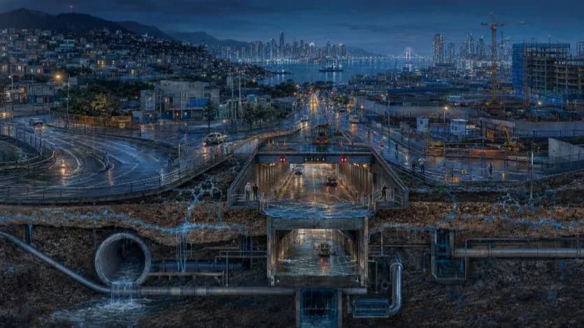
The city is not only building higher along the shoreline. It is placing more stress on the network below everyday traffic: sewer lines, stormwater pipes, backfilled road cuts, underpasses, utility corridors, construction sites and drainage systems that carry the city before they fail in public.
That network is becoming harder to manage. Busan is expanding underground transport, repairing old infrastructure, scanning roads for cavities, installing smart barriers, testing AI-based flood systems and approving redevelopment in districts already shaped by water and dense traffic. Each program may have its own file. Each project may have its own review. But water does not move by department. Soil does not move by permit. Traffic does not wait for agencies to reconcile their records after a road closes.
The public record shows a city with many safety programs. It does not yet show, in one place, how those programs perform when water rises, ground settles or redevelopment adds more load to roads, pipes and drainage systems residents rarely see.
That is why the question should not be narrowed to whether one underpass is safe, one road has a cavity or one coastal tower can be engineered to stand. Busan’s planning problem is broader. The city needs a way to connect road subsidence, underpass flooding, GPR surveys, old-pipe exposure, groundwater monitoring, drainage capacity, construction records and redevelopment approvals before the road surface becomes the first warning.
The road network sits on pipes, backfill and water
Busan’s subsidence record points first to infrastructure residents do not see.
The city’s documented cases are led not by spectacular tunnel failures, but by damaged sewer pipes, damaged water lines and poorly compacted backfill beneath ordinary roads. Those categories matter because they move the story away from spectacle. A dramatic road collapse may be the moment residents notice the danger, but the underlying process often begins earlier, inside old pipes, loose fill, leaking joints or construction zones where groundwater and fine soil are not fully controlled.
A road does not need a dramatic underground void to become unsafe. A cracked sewer pipe can remove soil gradually, pulling fine material into the pipe and leaving the pavement above to carry traffic on weaker ground. A leaking water line can loosen the fill around it. A trench that was not compacted evenly can settle after rain and repeated vehicle loads. By the time drivers feel a dip or hear the impact of a wheel crossing uneven pavement, the failure may have been developing below the street for months.
Heavy rain then acts less like a single cause than a stress test. Stormwater pushes more water through old pipes and drainage channels. It raises pressure in places where joints, backfill or underground utilities have already weakened. In a coastal city with old infrastructure, dense roads and repeated excavation, rain can turn a hidden defect into a visible closure.
That makes subsidence a road-network problem, not only a geotechnical problem. A collapse in one lane can redirect traffic, delay emergency response, expose old utility corridors and force repairs on roads already carrying commuter and construction pressure. The ground may fail locally, but the disruption spreads through the city.
Naeseong belongs in that wider frame. Based on the public record so far, the episode sits closer to a post-construction verification problem than to a confirmed sinkhole event. City officials said inspections found no major underground cavity and described the risk of dangerous collapse as low. That conclusion narrows the question rather than ending it. If the road is not failing over a cavity, the next evidence should show whether settlement around backfilled sections is slowing, whether pavement deformation is stabilizing and whether rainfall changes the readings.
For residents, that is the difference between reassurance and verification. Reassurance says the risk is low. Verification shows the scan coverage, survey depth, pavement movement, rainfall-linked readings, 3D surface measurements and post-repair checks that support the conclusion.
Underpasses are bottlenecks, not standalone structures
An underpass is not only a flood-prone facility. It is a low point in the traffic network, a drainage-dependent corridor and, during a storm, a decision point for police, firefighters, commuters and emergency vehicles.
The Choryang No. 1 Underpass disaster forced Busan to treat underpass flooding as a system problem. After that accident, the city announced smart vehicle-blocking systems linked to water-level sensors, warning signs, lights, broadcasts and remote barriers. It later introduced emergency-escape-route plans for flooded underpasses and built flood-information platforms meant to give residents and officials more warning.
Those measures matter. They show that Busan’s safety policy has moved beyond manual response and post-accident repair. But an underpass system is proven only in operation. A barrier protects drivers only if it closes before cars enter rising water. A flood map helps residents only if it updates fast enough to guide decisions during a storm. An escape route matters only if people can reach it under poor visibility, panic, stalled traffic and rising water.
The public figures around Busan’s underpasses also show why classification itself needs clearer explanation. Public records and reports have described different groups of facilities: total underpasses, flood-prone underpasses, underpasses targeted for smart vehicle-blocking systems, underpasses selected for emergency escape routes and underpasses legally required to install vehicle-blocking facilities. Those numbers may be reconcilable. They may reflect different laws, ownership structures, design conditions or risk categories. But residents should not have to reconstruct the categories on their own to understand which underpasses are protected and which are not.
A road-network safety record would answer the question differently. It would not stop at whether a device was installed. It would show which underpasses are low points, which are connected to high-risk drainage basins, which have barriers, which have escape routes, when those barriers last activated, how long closure took, whether sensors failed, how traffic was diverted and whether emergency vehicles had alternative routes.
In that sense, the underpass is a test of the whole city. If the record remains facility by facility, residents see fragments. If the record follows the road network, they can see how water, traffic and emergency response meet in one place.
Underground construction adds a second layer
Large underground projects do not only create tunnels and rail lines. They disturb the ground that existing roads, pipes and neighborhoods already depend on.
That is why Busan’s recent underground incidents should not be collapsed into one story about a sinking city. They belong to different files.
Naeseong and nearby road corridors raise questions about residual settlement, backfilling, pavement stability, drainage and monitoring after underground road construction. The issue is not whether officials can say no major cavity was found. The issue is whether the public can see the measurements showing that movement is slowing and repairs are holding.
The Sasang-Hadan urban railway cases point in a different direction. Public audit findings and subsequent reporting placed repeated failures around groundwater, fine soil loss, cutoff work, grouting and construction supervision. Rain mattered, but the record does not support a simple rain-only explanation. The harder question is whether the construction system kept water and soil where they were supposed to remain.
That distinction matters for accountability. A residual-settlement problem requires one kind of record: settlement readings, pavement deformation, scan coverage and post-repair monitoring. A groundwater and soil-loss problem requires another: groundwater levels, inflow volumes, grouting logs, cutoff-wall performance, soil-loss indicators, monitoring alerts and the actions taken by supervisors when warning signs appeared.
Both cases lead back to the same public demand. Residents need more than a conclusion that a site is safe or that a risk is low. They need to know what was measured, where it was measured, how readings changed over time and what action followed.
Busan may already hold much of the relevant data inside agency files, contractor reports and monitoring systems. The planning question is whether those records can be read in time, by location, before the next road surface becomes the first warning.
Busan has systems. It lacks a network operating record.
Busan has not treated flood and ground risk as if it were invisible.
The city has announced smart underpass barriers, emergency escape routes, urban flood information systems, AI and XR-based pilots, GPR surveys, ground-subsidence postings and broader monitoring programs. The city also posts GPR survey updates and ground-subsidence incident information through public channels. Those records matter. They show activity, investment and a growing safety vocabulary.
But installation records do not answer the harder question. A device is not the same as a performance record. A platform is not the same as a field result. A survey posting is not the same as a public explanation of what was found, what was repaired and whether the same location was checked again.
Busan’s public record still leans more heavily toward system names than operating results. Residents can find announcements about smart underpasses, emergency routes, flood platforms and AI pilots. They can find GPR postings and subsidence incident records. What remains harder to find is a single public record that says how each system performed when conditions became dangerous: when rain intensified, when a sensor crossed a threshold, when traffic had to be blocked, when a cavity was repaired or when a road was scanned again after repair.
The difference matters because safety systems fail in operational details. A barrier that closes late is not the same as a barrier that closes on time. A sensor that works in routine tests may still fail during debris, power loss, communication delay or local flooding. An AI model that identifies risk in a pilot setting may not deliver the same value unless the city reports how often it warned too late, warned unnecessarily or missed a real event. A GPR survey program may expand in length and frequency while still leaving residents unable to see which locations remain under observation.
The same problem appears in ground-subsidence management. A GPR posting can confirm that a survey took place. It does not, by itself, tell residents whether a detected cavity was urgent, whether it was repaired, whether a post-repair scan was done or whether the same road later showed new movement. A subsidence incident list can show that a failure occurred. It does not automatically show whether the cause was removed or only the surface was restored.
Busan’s next safety test is therefore not the purchase of another device or the launch of another platform. The city already has devices and platforms. The test is whether it can turn them into a road-network operating record residents can read: barrier activation times, closure delays, sensor failures, AI missed-warning rates, escape-route completion, GPR cavity grades, repair dates, post-repair scan results, resubsidence checks, rainfall-linked readings and road reopening times.
That record would change the public meaning of safety. Instead of asking residents to accept that a system exists, it would show how the system behaved. Instead of announcing that a risk is low after an inspection, it would show the measurements that made that conclusion credible.
In a city facing heavier rain, older underground utilities and deeper construction, public trust will depend less on the number of safety programs Busan names than on the performance data it is willing to publish.
Redevelopment adds load to the same network
Redevelopment does not sit above the road network. It adds weight to it.
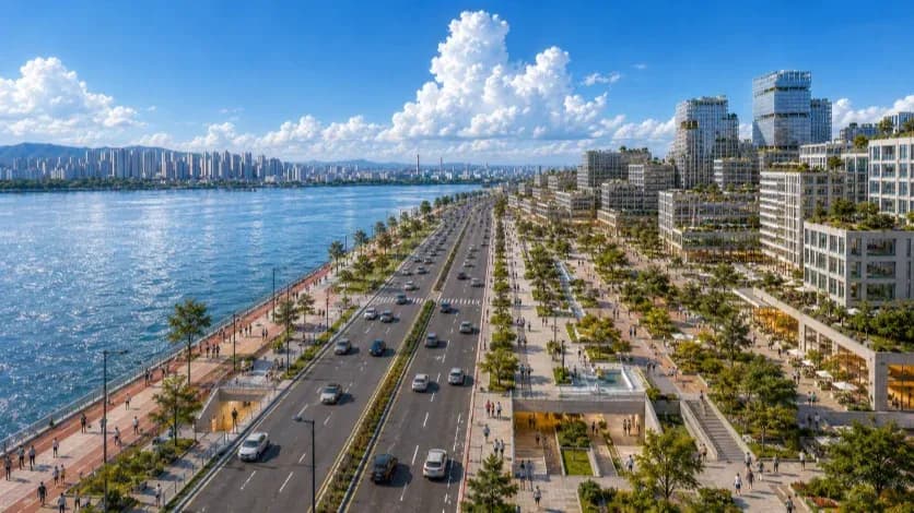
That is why the Samick Beach reconstruction in Namcheon-dong matters in this story, but not as a simple high-rise fear case. The project is moving through a revised approval process, with a plan to rebuild the aging complex into a 59-story, 3,060-unit coastal residential development. The height is visible. The deeper planning question is less visible: what happens when a major redevelopment adds residents, vehicles, underground parking, excavation, utility work, stormwater demand and emergency-access pressure to a district already shaped by roads, pipes and water?
Samick Beach should not be treated as proof that coastal high-rises are unsafe. The public record does not support that claim. The project should be treated as something more specific: a test of whether Busan’s current approval process can show how a major redevelopment accounts for climate-era water risk and underground-system pressure before construction begins, not after residents move in.
The timing matters. The project’s environmental review record entered public view in 2021. Its revised plan is moving through public inspection in 2026. Between those two points, Busan expanded its public language around underpass flooding, ground-penetrating radar, ground subsidence, AI-based flood response and underground safety monitoring. The city has also continued to document heavier rainfall, rising seas and coastal flood exposure. The question is therefore not only what Samick Beach plans to build. The question is which version of Busan’s risk knowledge the approval record now uses.
Busan’s own climate record makes that question more concrete. The city says its recent 30-year rainfall normal has increased compared with the previous climate normal, while sea level in Busan rose over the long term. Those numbers do not decide the Samick Beach case. They explain why a 2026 approval file should not read like a 2021 risk file.
A redevelopment review that once looked adequate can become incomplete if the city’s risk environment changes faster than the approval file. Sea-level assumptions, storm-surge scenarios, wave-overtopping models, basement flood levels, drainage capacity and groundwater monitoring cannot be treated as background details. They determine whether a dense district can function during the kind of storm that does not attack the tower first, but the road, the basement ramp, the access route and the pipes around it.
The public should be able to answer several concrete questions from the approval record. What flood level shaped the underground parking design? Where will electrical rooms, pump rooms, emergency generators and key mechanical systems sit in relation to that level? How much rainfall can the surrounding stormwater network handle if high tide slows discharge? What happens if heavy rain, wave overtopping and drainage backflow occur in the same period? How will excavation affect groundwater, nearby roads and adjacent utilities? Which monitoring results will be disclosed during construction?
Those questions do not block redevelopment. They define the standard for redevelopment in a city that has already learned the cost of late adaptation. Samick Beach matters less as a symbol of height than as a test of load: what happens when a major coastal redevelopment places more people, vehicles, pipes, basements and drainage demands onto a district already shaped by water and underground infrastructure?
The vulnerable point may not be the tower
In Busan’s road network, the vulnerable point may not be the tower itself. It may be the underpass, the sewer line, the backfilled trench, the basement ramp or the access road that carries water before anyone calls it a disaster.
The most visible part of a high-rise district is rarely the part that fails first. A tower’s height attracts public attention because it changes the skyline. It affects views, density, traffic, construction cost and neighborhood identity. But in a climate-stressed urban district, the systems that decide whether a building can function during a storm often sit below the lobby or outside the parcel: underground parking, electrical rooms, pump rooms, emergency generators, communication equipment, drainage connections, backflow-prevention systems, access roads and stormwater outfalls.
A high-rise can be structurally engineered to stand. The harder test is whether its lower and surrounding systems can continue to work when rainfall, tide, storm surge and local drainage limits converge. If floodwater reaches the basement, the building may remain upright while daily life fails: cars trapped, elevators disabled, pumps overwhelmed, power systems threatened and residents forced to navigate a vertical building without the systems that make vertical living possible.
The same logic applies outside the building line. A redevelopment does not stand alone on its own foundation. It depends on surrounding roads, sewer pipes, stormwater drains, outfalls, pump capacity and emergency access. If heavy rain arrives during high tide, drainage can slow. If wave overtopping pushes water inland, roads can become channels. If old pipes or nearby utility trenches have weak points, water can move through the ground in ways that do not respect the edge of a project site.
Busan already treats many of these issues as technical review categories. The city’s building environmental review criteria refer to groundwater impacts, excavation methods, sewer capacity, stormwater runoff, underground development, ground stability, settlement prevention and monitoring plans. That recognition is important. It means the city does not need to discover a new safety language. It needs to make the existing one legible in the public record.
For a major redevelopment, the approval record should show more than architectural form and engineering compliance. It should show the flood level used for basement design, the location of critical equipment, the capacity and redundancy of pumps, the protection of emergency power, the design of flood barriers, the expected performance of backflow valves and the stormwater assumptions applied to nearby infrastructure. It should also show how groundwater will be monitored during excavation and how nearby settlement will be tracked while the site is opened, supported and rebuilt.
Those records matter because urban risk often reaches residents indirectly. It does not always arrive as a wave hitting a tower or a road collapsing in one dramatic moment. It can arrive as water backing through drainage, as a basement ramp becoming an intake, as a pump losing power, as an access road closing before emergency crews arrive, or as groundwater movement affecting streets and utilities around a construction site.
The tower may remain standing while the systems around it fail.
Busan already knows the cost of late adaptation
Busan does not have to imagine what delayed adaptation looks like. It has already seen it.
Marine City offers the clearest public-works version of the lesson. The district became one of Busan’s best-known symbols of high-rise coastal living, but repeated wave overtopping and storm damage later pushed the city toward a major offshore defense project. The planned submerged breakwater is not a design flourish. It is an expensive correction to a coastal exposure that became politically and physically harder to ignore after residents, roads and commercial spaces had already been placed behind the waterfront.
That does not make Marine City a failure story in simple terms. It remains one of Busan’s most valuable and visible districts. But it shows the order of operations that future planning should avoid. When dense development comes first and stronger defenses follow later, the cost no longer belongs only to developers, residents or engineers. It becomes a public infrastructure question.
Hillstate Ijin Bay City shows a sharper version of the same principle. The issue there was not tower height in the abstract. The dispute centered on coastal protection, flood modeling, unfinished defense conditions and the official decisions that allowed residents to move into a building before the surrounding protection was fully resolved. After Typhoon Hinnamnor, the damage did not remain an engineering detail. It moved into court, where flood assumptions, defensive works and administrative responsibility became part of the public record.
Those cases should not be used carelessly. They do not prove that every coastal redevelopment in Busan will face the same outcome. They do not prove that Samick Beach is unsafe. They prove something narrower and more useful for public scrutiny: flood modeling, defense conditions, approval sequencing and surrounding infrastructure cannot be treated as secondary details.
The lesson for Busan is procedural as much as technical. A redevelopment file should not only show that a building meets structural standards. It should show whether the surrounding defenses, drainage systems and underground protections are complete, funded, sequenced and enforceable before occupancy. If any part of that protection depends on a separate public project, a later schedule or a neighboring facility, the approval record should say so plainly.
Late adaptation can still reduce future damage. But it also reveals what the original approval process did not fully settle. In a city building denser districts around roads, water and underground systems already under pressure, safety should not depend on whether a future storm forces the missing details into view.
The missing map
Busan already has many pieces of a modern safety system.
It has flood maps, underpass controls, emergency-route plans, AI-based pilots, GPR survey postings, underground-safety data, redevelopment files, environmental review procedures and climate-risk programs. The city can point to systems that did not exist a decade ago. It can point to sensors, maps, barriers, studies and new technical language. The problem is not that Busan has ignored the ground below it or the water around it.
The problem is that those pieces still do not add up to a public record strong enough for the city Busan is becoming.
Busan’s planning problem is not that safety categories are absent from review. They exist. The problem is that project-level review, flood mapping, GPR surveys, old-pipe data and coastal-defense planning still appear as separate records, while water and ground movement connect them in the same city.
A resident can see a redevelopment notice in one place, a flood map in another, a GPR survey posting somewhere else and an underpass safety announcement through a different channel. A road can be scanned, a cavity can be repaired, an underpass can receive a barrier, an AI pilot can be tested and a redevelopment project can move through review. But the public still struggles to answer one location-based question: what does the city know about this place, and how has it tested the systems meant to protect it?
That is the missing map.
The map Busan needs is not only a graphic. It is a public method of accountability. For an underpass, it would show flood history, sensor coverage, barrier activation records, closure delays, emergency escape routes and inspection dates. For a road at risk of subsidence, it would show old pipes, past incidents, GPR findings, repair records, post-repair scans and settlement monitoring. For a redevelopment site, it would show flood levels, drainage capacity, groundwater monitoring, excavation zones, emergency access, basement protections, sewer capacity, stormwater assumptions and the status of any defense or infrastructure the project depends on.
Such a record would not eliminate risk. No coastal city can make that promise. Heavier rainfall, rising seas, aging pipes and deep excavation will continue to test Busan’s infrastructure. But a connected public record would change the way risk is governed. It would move safety from reassurance to evidence. It would allow residents to see not only that a system exists, but how that system performed, when it failed, what was repaired and what remains under observation.
That distinction now matters more than before. Busan is no longer only maintaining an old city. It is also building a deeper and denser one. Roads are being opened, utilities replaced, tunnels driven, rail lines extended, underpasses monitored and redevelopment districts rebuilt into more vertical neighborhoods. Each project may pass its own review. Each system may satisfy its own standard. Yet climate risk does not arrive by department, by contract or by permit file. Water moves through districts. Groundwater moves through excavations. Soil moves through broken pipes. Floodwater enters the lowest available opening. Emergency response depends on the weakest connection in the system, not the strongest document in the file.
The city’s next safety policy should therefore be measured not by the number of devices it installs or the number of platforms it launches, but by whether residents can read the evidence before the next road sinks, the next underpass closes or the next redevelopment adds pressure to a drainage and road network residents cannot see.
Safety, in the Busan now being built, cannot remain a conclusion issued after inspection. It has to become a record the public can test.
Editorial Context
"Independent journalism relies on radical transparency. View our full log of editorial notes, corrections, and project dispatches in the Newsroom Transparency Log."
Reader Pulse
The report's impact signal
Be the first to provide a reading pulse. These collective signals help our newsroom understand the impact of our reporting.
Join the discussion
A more thoughtful conversation, anchored to the story
Atlantic-style discussion for this article. One-level replies, editor prompts, and moderation-first participation are now powered directly by Prisma.
Discussion Status
Open
Please sign in to join the discussion.
The Weekly Breeze
Independent reporting and analysis on Busan,
Korea, and the broader regional economy.