Busan Tests Public-Led Redevelopment in Sinpyeong 2
Busan’s Sinpyeong 2 redevelopment is being framed as design innovation. Its deeper test is whether public planning can secure river access, industrial buffers and public routes before the site becomes another closed apartment compound.

Busan’s public-led planning study in Saha-gu will test whether redevelopment can open a lasting public route to the Nakdonggang River, not just build new apartments near it.
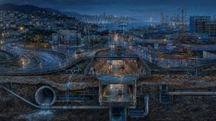
Busan’s public-led planning study for the Sinpyeong 2 Redevelopment Project could test whether the city can repair an older industrial riverfront in Saha-gu, where the Nakdonggang River remains close on the map but cut off from daily life by a wide industrial road, an aging factory district and the risk of closed apartment compounds.
Busan’s latest redevelopment announcement looks narrow at first: a basic planning study for the Sinpyeong 2 Redevelopment Project in Saha-gu. The site, however, turns a local housing renewal plan into a larger test for Western Busan.
In Sinpyeong 2-dong, the question is not only whether old housing will be replaced by new apartment towers. The harder question is whether Busan can use public planning to reopen a route to the Nakdonggang River, a major natural asset that sits close on the map but remains cut off from daily life by an industrial road, an aging factory district and the familiar pattern of closed apartment compounds.
The city is applying its Busan-style Improvement Plan Formulation Request System, a public-led redevelopment planning process that allows the municipality to shape the basic direction of a redevelopment plan before private feasibility and density targets define the project. That distinction matters. Sinpyeong 2 is not a public redevelopment project in the strict sense. Public agencies are not taking over the development. Instead, Busan is entering the planning stage early enough to decide what the project must provide beyond housing supply.
That early intervention gives the city an unusual opportunity. In many redevelopment projects, small streets disappear into large apartment blocks, and public movement is redirected around private compounds. Open spaces shown in planning documents can later become managed gates, resident-only paths or amenities that technically exist but no longer serve the surrounding neighborhood. In Sinpyeong 2, that risk carries greater weight because the route through the site may become part of the neighborhood’s access to the Nakdonggang River.
The site sits at a difficult urban seam. Housing, school life, the Sinpyeong–Jangnim General Industrial Complex, a wide industrial road and the river press against one another. A conventional redevelopment plan could treat the road as a boundary, the industrial complex as a nuisance and the river as a view. A stronger public plan would treat all three as planning obligations: safe crossings, legally protected pedestrian routes, industrial buffers and public spaces that remain open after the apartments are occupied.
That is why Sinpyeong 2 should not be read as another river-view apartment story. Its significance lies in whether Busan can repair an older industrial riverfront rather than simply build near it. Gangseo is building new waterfront urbanism on newly planned land. Saha has a harder task: to reconnect neighborhoods already shaped by factories, roads and decades of uneven development to the river beside them.
The success of the project will not be measured by the height of its towers or the language of design innovation in a city press release. It will be measured by whether residents, students, workers and nearby communities can move safely through the site, cross the industrial road and reach the Nakdonggang River without depending on the goodwill of a future apartment management office.
Public-led planning, not public redevelopment
The planning system behind Sinpyeong 2 needs careful language. The project is not public redevelopment in the strict sense. A public agency is not taking over the site, replacing the developer or becoming the main project operator. The change comes earlier and more quietly, at the stage where the redevelopment problem is defined.
Busan’s Improvement Plan Formulation Request System gives the city a role before private feasibility narrows the project into floor-area ratios, unit counts, parking ramps and sales assumptions. Residents may request the formulation of an improvement plan, but the public sector can step in to shape the basic direction of that plan. In practical terms, the city gains a chance to decide what the redevelopment must solve before the project becomes a closed financial exercise.
That difference matters in Sinpyeong 2. A conventional redevelopment process could begin with the housing block and treat everything around it as a constraint: the industrial road as a boundary, the factory district as an external nuisance and the Nakdonggang River as a marketing view. Public-led planning can reverse that order. It can start with the road, the river, the school, the industrial edge and the surrounding neighborhood, then ask how housing should fit into that structure.
The system also changes the meaning of public value. In many redevelopment debates, public value appears late, often as a park, a road widening, a donated facility or a line in a planning document. In Sinpyeong 2, that would be too weak. Public value needs to mean protected pedestrian routes, safe crossings over the industrial road, open ground-floor uses, buffers against industrial impacts and access to the Nakdonggang River that remains public after the apartments are occupied.
The city’s approach has practical merit. Earlier planning can reduce repeated revisions, lower the initial planning burden on residents and bring infrastructure, design and public-space questions into the same discussion before association politics and market logic narrow the options. It can also give the city a clearer position when later decisions about density, circulation, parking and public facilities begin to compete with one another.
The comparison with Seoul is useful but limited. Seoul’s fast-track planning model works in a redevelopment market where private demand is strong and public intervention often manages speed, design quality and conflict. Busan faces a harder local condition. In Saha-gu, public planning must work with weaker market pressure, population decline, an aging industrial base and a riverfront already cut off by decades of infrastructure built for production and logistics.
That makes Sinpyeong 2 a different kind of test. The point is not whether Busan can shorten a procedure. The point is whether early public planning can keep the project from becoming another apartment compound that turns its back on the surrounding city. The city’s role will matter only if the basic direction study fixes public access, industrial buffers and neighborhood connections before later design and business decisions reduce them to optional features.
The risk is clear. A public-led process can still produce a private enclave if its public routes are not legally protected, if open spaces are managed as resident amenities, or if the industrial road remains a hard barrier between the district and the river. A planning request system does not guarantee a public city. It only creates the moment when a public city can be required.
Sinpyeong 2 will show whether Busan can use that moment well. The test will not be found in the language of design innovation. It will be found in the plan drawings, access rules, land-use conditions and legal protections that decide who can pass through the site, who can reach the Nakdonggang River and whether the redevelopment repairs the neighborhood or closes it again.
A redevelopment site shaped by roads, factories and a river
Sinpyeong 2 does not fit the usual redevelopment script of an aging residential block waiting for replacement. The site sits at a hard urban seam in Saha-gu, where housing, school life, industrial production, a wide road corridor and the Nakdonggang River press against one another.
That geography changes the meaning of redevelopment. In many older residential districts, the main planning questions concern density, access roads, schools, parks and the replacement of low-rise housing with apartments. Sinpyeong 2 carries those questions, but it also carries a larger one: whether a district built near a major river can regain access to that river after decades of industrial and road infrastructure have stood in between.
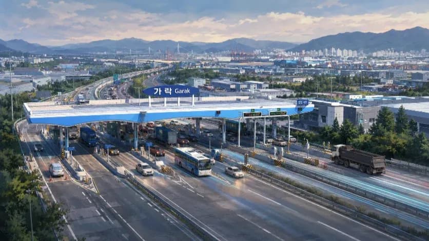
The river-facing edge carries the most important test. A wide industrial road separates the neighborhood from the Nakdonggang River. That road does more than move traffic. It defines what residents can reach, how children and older residents move through the area, where public space can function and whether the river becomes part of everyday life or remains a distant landscape behind lanes of vehicles.
The industrial edge adds another layer. The Sinpyeong–Jangnim General Industrial Complex is not a background condition. It will shape the redevelopment through truck movement, noise, air quality, parking demand, worker traffic and the need for buffers between production and housing. A plan that treats the industrial complex as something to screen off will miss the larger urban problem. The district needs a working boundary, not a decorative edge.
The surrounding residential and school edges connect the site to existing daily life. That connection gives the project a responsibility beyond future apartment residents. If the redevelopment absorbs local paths into a private compound, surrounding residents may lose routes they already use or could need in the future. If the plan keeps those routes open and ties them to safer crossings toward the river, the project can serve a wider district.
That makes the internal pedestrian network more than a design feature. A path through Sinpyeong 2 could become part of the public route from the neighborhood to the Nakdonggang River. A central plaza could become a shared civic room for residents, students, industrial workers and nearby communities. Ground-floor facilities could support daily life instead of turning inward as apartment amenities.
The opposite outcome remains possible. A conventional redevelopment plan could place towers above a landscaped podium, line the river-facing road edge with walls, ramps and buffers, and present the river as a view from upper floors. That would renew the housing stock but leave the old structure intact: a neighborhood beside the river, not connected to it.
Sinpyeong 2 matters because the site exposes that difference. River proximity alone does not create public value. Public value begins when the plan secures movement: through the district, across the industrial road and toward the Nakdonggang River. Without that movement, the project would only place new housing inside an old pattern of separation.
Western Busan’s split: new land in Gangseo, old riverfronts in Saha
Sinpyeong 2 also belongs to a wider imbalance inside Western Busan. The contrast is no longer only between eastern and western Busan. A sharper divide now runs within the west itself: between newly planned Gangseo and the older Nakdonggang River corridor of Saha, Sasang and Buk-gu.
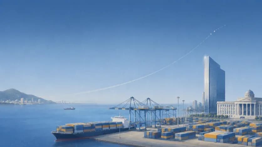
Gangseo has become the place where Busan can still draw large plans on relatively open land. New towns, logistics districts, airport-linked projects and industrial clusters give the area a growth narrative that is easier to explain and easier to market. Roads can be widened before residents arrive. Parks can be drawn into master plans. Waterfront language can be built into the identity of a new district from the beginning.
Saha faces a different task. The district does not have an empty waterfront waiting for a master plan. Its river-facing neighborhoods already carry the marks of Busan’s industrial decades: factories, logistics roads, aging housing, small workshops, narrow local streets and a population structure shaped by decline and aging. Planning in Saha therefore begins with conflict, not blank space.
That difference matters for the meaning of redevelopment. In Gangseo, waterfront development can be framed as expansion. In Saha, riverfront redevelopment must be framed as repair. The goal cannot be only to build new housing near the Nakdonggang River. The harder task is to recover access to a river that older neighborhoods have lived beside but rarely used as part of daily life.
Sinpyeong 2 sits directly inside that problem. The site is close enough to the river to support a redevelopment narrative built around views and design. Yet the neighborhood’s real condition is defined by distance created by infrastructure. A wide industrial road, nearby factories and the pattern of large private apartment compounds can all keep the river out of public reach even when it remains physically nearby.
That makes the project a test of balance in a concrete sense. Balanced development does not mean distributing apartment projects across districts. It means giving older districts the public infrastructure that new districts receive at the planning stage: safe routes, usable open space, connected parks, transit access, pedestrian networks and streets that do not treat residents as an afterthought.
A redevelopment plan that only adds new towers would not answer Saha’s problem. New housing may improve the immediate site, but it would not change the older structure that has separated the district from the Nakdonggang River. A stronger plan would use redevelopment as a lever to connect the school and residential edges, the industrial-complex edge, the river-facing road and the wider public realm.
This is where Busan’s public-led planning system gains importance. Private redevelopment can deliver buildings. Public planning has to decide whether those buildings repair the district around them. In Sinpyeong 2, that means asking whether redevelopment can create public routes where industrial infrastructure created barriers, and whether those routes can remain open after the project becomes a private apartment complex.
Western Busan does not need only new growth zones in Gangseo. It also needs a method for fixing established neighborhoods along the Nakdonggang River without erasing their public life or turning access to the water into a private amenity. Sinpyeong 2 will show whether Busan can begin that work at the scale of one redevelopment site.
The river is close, but access is still blocked
For Sinpyeong 2, the Nakdonggang River is not yet a public amenity. It is close on the map, visible in the planning imagination and valuable in any redevelopment narrative. But proximity does not create access. A river can sit beside a neighborhood for decades and still remain outside daily life if roads, industrial land and private compounds control the routes toward it.
That is the central problem in Sinpyeong 2. The river-facing edge is not an open civic front. It is mediated by a wide industrial road that was built for movement, logistics and production rather than neighborhood access. That road carries the legacy of a period when the western edge of Busan was planned around factories, freight and infrastructure. It helped the city grow. It also turned parts of the Nakdonggang River into a background landscape for residents who lived nearby but could not easily reach it.
A redevelopment plan can respond to that condition in two very different ways. The weaker response would use the river as a selling point while leaving the barrier in place. New towers could face the water. Higher floors could capture views. Landscaping could soften the road edge. The district would look more refined, but the route to the river would remain inconvenient, unsafe or indirect for surrounding residents.
The stronger response would treat access as the core of the plan. That would require more than a line of trees or a plaza near the road. It would require safe crossings, clear pedestrian routes, bicycle connections, visible entrances, traffic-calming measures and public spaces that guide people from the neighborhood toward the water. The plan would need to show how a child, an older resident, a worker from the industrial complex or a person from a nearby block could move through the site and reach the Nakdonggang River without passing through a controlled residential gate.
This is where public-led planning should matter. A private redevelopment plan often treats the road edge as a boundary to be managed. Public planning can treat it as a connection to be built. The difference may appear small in drawings, but it changes the project’s public value. A buffer protects an apartment complex from the road. A connection gives the wider neighborhood a way to reach the river.
Sinpyeong 2 therefore needs a river-access plan, not only a river-facing design. The internal pedestrian axis must connect to the river-facing edge. The edge must connect to a safe crossing. The crossing must connect to the riverfront path or open space beyond the road. Each link has to work as part of one public route. If one link is missing, the project will keep the old separation in place.
The same test applies after completion. A passage that exists only inside a privately managed apartment compound cannot serve as durable public access. A gate, a card reader, a security desk or a residents-only rule can turn an open-looking plan into a closed route. In Sinpyeong 2, such a closure would do more than inconvenience neighboring residents. It could privatize the most direct path toward the Nakdonggang River.
That is why the city’s basic direction study must go beyond design language. It should define which routes remain public, how they are protected, who manages them and how they connect to the industrial road crossing. Without those details, the river will remain a view rather than a public space. With them, Sinpyeong 2 could begin to change the older relationship between Saha-gu and the Nakdonggang River.
The project’s real question is therefore simple. Will redevelopment bring the neighborhood closer to the river, or will it place new buildings beside the same barrier?
The industrial road is the real design question
The most important design question in Sinpyeong 2 may not be the towers. It may be the road.
The wide industrial road along the river-facing edge is the physical line that decides whether the Nakdonggang River becomes part of the district or remains outside it. It separates housing from water, local movement from riverfront space and redevelopment ambition from daily use. Without a plan for that road, any promise of river access will remain incomplete.
The road cannot simply disappear. It still serves industrial movement, freight circulation and the wider transport structure of western Busan. That reality makes the planning task harder. The goal is not to erase an industrial road but to stop it from functioning only as a barrier. A serious plan must hold two functions together: traffic movement and public crossing.
That requires a different design language from the one often used in apartment redevelopment. A landscaped edge is not enough. A sound wall is not enough. A setback with trees is not enough. Those treatments may protect a new apartment complex from the road, but they do not help the surrounding neighborhood reach the river.
The road-facing edge needs to work as a public threshold. That means crossings placed where people actually move, not only where traffic engineering finds them convenient. It means visible pedestrian routes from the existing neighborhood through the redevelopment site toward the river-facing edge. It means bicycle connections that do not break at the property line. It means ground-floor uses that face the street, not a row of blank walls, parking ramps or service entries.
The project also needs to account for the different people who would use that edge. Apartment residents are only one group. Nearby residents, students, older people, workers from the Sinpyeong–Jangnim General Industrial Complex and people moving toward the riverfront all need routes that are legible and safe. A public plan should not design the road edge only from the perspective of future apartment security.
The planning challenge is practical. Where will people cross? How long will they wait? Can a child or an older resident move from the residential side to the river-facing side without navigating heavy traffic, hidden entries or indirect detours? Will a bicycle route continue across the project boundary? Will the public space along the road be comfortable enough to use, or will it function only as a visual buffer beside traffic?
These questions are more important than the height profile in the rendering. A tower can create a skyline. A crossing can change daily life. If the industrial road remains a hard edge, Sinpyeong 2 will renew the housing stock without repairing the neighborhood’s relationship to the Nakdonggang River. If the road becomes a managed point of connection, the project can begin to turn an industrial-era barrier into public infrastructure.
The city’s early planning role matters here because road-edge decisions are difficult to add later. Once tower placement, parking access, podium design and internal circulation are fixed, public routes become secondary adjustments. The basic direction study should therefore define the road-facing edge before private design logic closes it.
Sinpyeong 2 should be judged by whether the industrial road is treated as a boundary or as a public interface. A boundary protects the new complex from the city around it. A public interface allows the city to pass through the redevelopment and reach the river.
Redevelopment can create a new barrier
The industrial road is the existing barrier in Sinpyeong 2. Redevelopment could create the next one.
Korea’s redevelopment projects often replace aging neighborhoods with cleaner streets, newer housing and better-managed open space. They also tend to replace older street networks with large private apartment compounds. Small paths disappear. Informal crossings vanish. Public movement is redirected around controlled blocks. What looks open in a rendering can become fenced, monitored or functionally private after residents move in.
That pattern matters in Sinpyeong 2 because the route through the site is not only an internal convenience. It could become part of the neighborhood’s path toward the Nakdonggang River. If that route is absorbed into a private apartment complex, the redevelopment may renew the buildings while weakening public access. The river would remain close, but the most direct path toward it could sit behind a gate.
This is not a minor management issue. Apartment security, resident privacy and maintenance costs often become powerful arguments after completion. A pedestrian route promised during planning can later be treated as a burden by the people who pay to manage the complex. A plaza can become a residents’ space. A passage can receive a card reader. A ground-floor route can be narrowed by signs, fences or security desks. Access can remain technically present while becoming socially discouraged.
For Sinpyeong 2, that would undercut the reason public-led planning matters. The city’s early role should not only produce a better site plan. It should prevent the public route to the Nakdonggang River from becoming dependent on future apartment management decisions. A river-access plan cannot depend on goodwill from a residents’ association or a security office.
The basic direction study therefore needs enforceable public routes. Internal pedestrian passages should be defined as public pedestrian passages, public open space, urban planning facilities or another legally durable form. Their hours, management rules, maintenance responsibilities and connections to the river-facing road edge should be fixed before later design decisions make them optional.
The same standard should apply to plazas and ground-floor facilities. If public value is used to justify planning flexibility, density incentives or design exceptions, the public must receive more than landscape. It must receive usable space. A plaza that only serves future residents is an amenity. A plaza that connects school life, nearby housing, industrial workers and the route to the river is public infrastructure.
This distinction will decide whether Sinpyeong 2 becomes different from conventional redevelopment. A closed compound would reproduce the old separation in a newer form: factories and roads on one side, private housing on the other, and the river beyond reach. An open plan would use redevelopment to stitch those pieces together.
The test is not whether the plan contains open space. The test is whether the open space remains open when ownership, management and security pressures arrive. Without legal protection, the route to the Nakdonggang River can close after the ribbon-cutting. With it, Sinpyeong 2 can turn redevelopment from a private replacement project into a public connection.
The industrial complex is not a backdrop
The Sinpyeong–Jangnim General Industrial Complex is not a backdrop to the Sinpyeong 2 Redevelopment Project. It is one of the conditions that will decide whether the project becomes a livable district or only a newer apartment block beside an older industrial zone.
The redevelopment site sits close to a working industrial area. That proximity cannot be handled through screening alone. Truck movement, parking demand, shift workers, noise, air quality, odor, lighting and the visual weight of industrial buildings all shape daily life. A plan that places apartments beside the complex without addressing those conditions would simply move new residents closer to old conflicts.
The stronger approach is not to pretend the industrial complex is temporary or irrelevant. The stronger approach is to design the boundary between production and housing. That boundary needs more than a line of trees. It needs a clear traffic structure, safe pedestrian routes, separated truck access where possible, buffers that reduce noise and dust, and public spaces placed where they can serve both residents and workers without creating new conflicts.
This is where Sinpyeong 2 differs from a conventional residential redevelopment site. The project cannot only ask how future apartment residents will enter their parking garages or reach internal amenities. It must ask how industrial workers move through the area, where trucks wait, where informal parking occurs, how students and older residents avoid heavy traffic, and whether public facilities can reduce pressure on streets already shaped by industrial use.
The proposed idea of shared or public parking near the industrial edge shows why this issue is complicated. Parking can help relieve pressure from the industrial complex and reduce disorder on local streets. It can also bring more vehicle movement into a residential edge if it is poorly placed. The question is not whether parking is public or private in name. The question is where vehicles enter, how pedestrians are protected and who manages the space after completion.
The same standard applies to ground-floor uses. Retail, cultural space or community facilities can help soften the boundary between housing and industry. But those uses must face real users, not only future residents. A small public facility that serves nearby workers, students and existing residents may do more for the district than a larger amenity hidden inside the apartment compound.
Environmental planning also has to be concrete. Industrial buffers should not be reduced to landscape decoration. The plan should address air quality, odor, noise, heat, nighttime lighting and the daily routes of freight vehicles. If those issues remain outside the redevelopment plan, they will return after completion as resident complaints, industrial friction and pressure for new barriers.
The public-led planning process gives Busan a chance to avoid that outcome. The city can define the industrial edge as a planning obligation before the site becomes a private development problem. That means treating the industrial complex not as something to turn away from, but as something the plan must manage openly.
Sinpyeong 2 will succeed only if it can hold housing, industry and river access in the same frame. A closed apartment complex would divide them again. A stronger plan would use buffers, public routes and shared facilities to make the boundary work. In an older industrial riverfront, that boundary may be as important as the buildings themselves.
What Busan must prove
Sinpyeong 2 will not be judged by the ambition of its rendering. It will be judged by the conditions Busan secures before the project moves into later design, business and management decisions. The public-led planning process gives the city an early position. That position matters only if it produces requirements that survive after the apartments are built.
The first test is the road. Busan must show how people will cross the industrial road between the redevelopment site and the Nakdonggang River. A river-facing plan without a crossing plan would leave the central barrier untouched. The city needs to define where crossings will be placed, how pedestrians and cyclists will reach them, how traffic speed and waiting time will be managed, and whether children, older residents and workers can use the route without taking long detours or navigating unsafe edges.
The second test is the public route through the site. A pedestrian axis inside Sinpyeong 2 cannot remain a design gesture. It must become a durable public passage. That requires more than open-looking space in a plan drawing. The route needs a legal and management structure that prevents later closure by gates, card readers, fences or residents-only rules. If the most direct path toward the river depends on future apartment management decisions, the public value of the project will remain fragile.
The third test is the industrial edge. The Sinpyeong–Jangnim General Industrial Complex will continue to shape the area through truck traffic, parking pressure, noise, air quality, odor and worker movement. Busan must show how the redevelopment plan handles that edge in detail. A strip of landscaping will not be enough. The plan needs buffers, circulation rules, truck and pedestrian separation, safer school routes, and facilities that reduce conflict between housing and production.
The fourth test is who the public spaces serve. A plaza inside the redevelopment site can become either a civic room or an apartment amenity. Ground-floor facilities can face the neighborhood or turn inward. Parking can reduce pressure on nearby streets or bring new traffic into residential edges. The plan must define users, hours, access rules and management responsibilities before those spaces are absorbed into private residential governance.
The fifth test is cost. Public value is not created by naming a space public. Someone must build it, maintain it and keep it open. Crossings, plazas, public pedestrian passages, bicycle links, industrial buffers, parking facilities and community spaces all carry costs. Busan must make clear which parts will be paid for by the city, the district, the redevelopment association, public contribution or related industrial-complex programs. Without that structure, public access can become either an unfunded promise or a burden shifted onto future residents.
The sixth test is whether the plan can resist the usual logic of redevelopment. As projects move forward, financial feasibility tends to narrow design choices. Parking access, tower placement, sales appeal and security concerns begin to dominate. If Busan’s basic direction study does not fix public obligations early, later decisions can reduce them to optional features. The city has to make public access part of the project’s structure, not a decorative layer added after the main scheme is set.
The final test is whether Sinpyeong 2 can become a model for older riverfront districts beyond one site. Saha, Sasang and Buk-gu contain other places where the Nakdonggang River lies close to daily life but remains cut off by roads, industrial land and aging urban fabric. A successful plan in Sinpyeong 2 would not need to be copied in form. It would need to create a method: start with the public route, treat industrial edges as planning obligations, protect access after completion, and measure redevelopment by what it gives back to the surrounding city.
That is the standard Busan has set for itself by entering the project early. If Sinpyeong 2 only delivers new housing with better architecture, it will remain a conventional redevelopment project with stronger design language. If it secures public routes, safe crossings, industrial buffers and open spaces that stay open, it can show why the planning request system matters.
The question is not whether Busan can draw a better apartment district. The question is whether the city can use redevelopment to repair an older industrial riverfront and make the Nakdonggang River reachable for the neighborhoods that have long lived beside it.
Editorial Context
"Independent journalism relies on radical transparency. View our full log of editorial notes, corrections, and project dispatches in the Newsroom Transparency Log."
Reader Pulse
The report's impact signal
Be the first to provide a reading pulse. These collective signals help our newsroom understand the impact of our reporting.
Join the discussion
A more thoughtful conversation, anchored to the story
Atlantic-style discussion for this article. One-level replies, editor prompts, and moderation-first participation are now powered directly by Prisma.
Discussion Status
Open
Please sign in to join the discussion.
The Weekly Breeze
Independent reporting and analysis on Busan,
Korea, and the broader regional economy.